Record added successfully

Petra, originally known to the Nabataeans as Raqmu, is a historical and archaeological city in southern Jordan. The city is famous for its rock-cut architecture and water conduit system. Another name for Petra is the Rose City due to the color of the stone out of which it is carved. Petra is one of the New7Wonders of the World.
Established possibly as early as 312 BC as the capital city of the Arab Nabataeans, it is a symbol of Jordan, as well as Jordan's most-visited tourist attraction.The Nabataeans were nomadic Arabs who took advantage of Petra's proximity to regional trade routes to establish it as a major trading hub. The Nabataeans are also known for their great ability in constructing efficient water-collecting methods in the barren deserts and their talent in carving structures into solid rocks.Petra lies on the slope of Jebel al-Madhbah(identified by some as the biblical Mount Hor) in a basin among the mountains which form the eastern flank of Arabah (Wadi Araba), the large valley running from the Dead Sea to the Gulf of Aqaba. It has been a UNESCO World Heritage Site since 1985.
The site remained unknown to the Western world until 1812, when it was introduced by Swiss explorer Johann Ludwig Burckhardt. It was described as "a rose-red city half as old as time" in a Newdigate Prize-winning poem by John William Burgon. UNESCO has described it as "one of the most precious cultural properties of man's cultural heritage".Petra was named amongst the New7Wonders of the World in 2007 and was also chosen by the Smithsonian Magazine as one of the "28 Places to See Before You Die".
Pliny the Elder and other writers identify Petra as the capital of the Nabataeans and the center of their caravan trade. Enclosed by towering rocks and watered by a perennial stream, Petra not only possessed the advantages of a fortress, but controlled the main commercial routes which passed through it to Gaza in the west, to Bosra and Damascus in the north, to Aqaba and Leuce Come on the Red Sea, and across the desert to the Persian Gulf.
Excavations have demonstrated that it was the ability of the Nabataeans to control the water supply that led to the rise of the desert city, creating an artificial oasis. The area is visited by flash floods, and archaeological evidence demonstrates the Nabataeans controlled these floods by the use of dams, cisterns and water conduits. These innovations stored water for prolonged periods of drought and enabled the city to prosper from its sale.
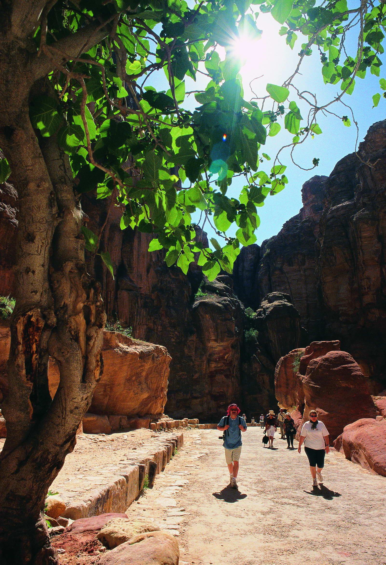
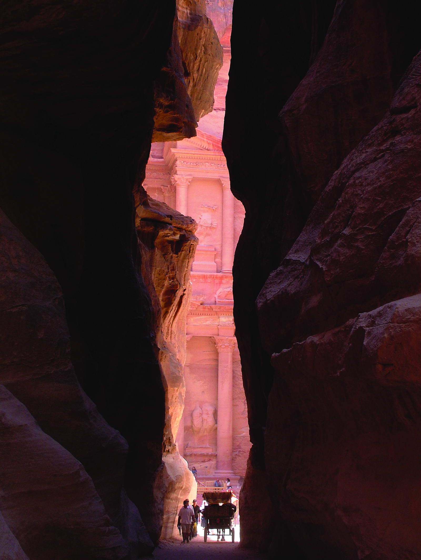
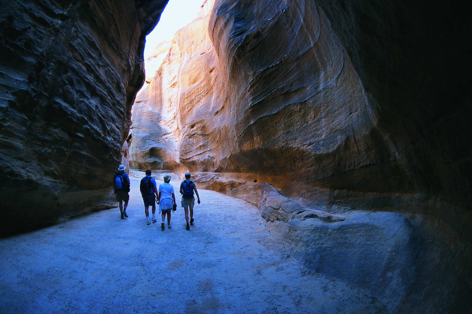
In ancient times, Petra might have been approached from the south on a track leading across the plain of Petra, around Jabal Haroun ("Aaron's Mountain"), the location of the Tomb of Aaron, said to be the burial-place of Aaron, brother of Moses. Another approach was possibly from the high plateau to the north. Today, most modern visitors approach the site from the east. The impressive eastern entrance leads steeply down through a dark, narrow gorge (in places only 3–4 m (9.8–13.1 ft) wide) called the Siq ("the shaft"), a natural geological feature formed from a deep split in the sandstone rocks and serving as a waterway flowing into Wadi Musa. At the end of the narrow gorge stands Petra's most elaborate ruin, Al Khazneh (popularly known as and meaning "the Treasury"), hewn into the sandstone cliff. While remaining in remarkably preserved condition, the face of the structure is marked by hundreds of bullet holes made by the local Bedouin tribes that hoped to dislodge riches that were once rumored to be hidden within it.
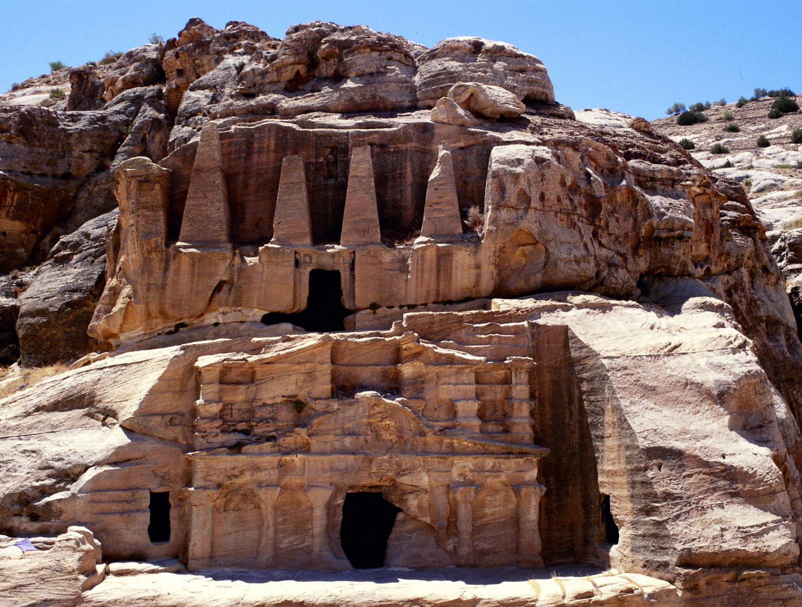
A little farther from the Treasury, at the foot of the mountain called en-Nejr, is a massive theatre, positioned so as to bring the greatest number of tombs within view. At the point where the valley opens out into the plain, the site of the city is revealed with striking effect. The amphitheatre has been cut into the hillside and into several of the tombs during its construction. Rectangular gaps in the seating are still visible. Almost enclosing it on three sides are rose-colored mountain walls, divided into groups by deep fissures and lined with knobs cut from the rock in the form of towers.
By 2010 BC, some of the earliest recorded farmers had settled in Beidha, a pre-pottery settlement just north of Petra. Petra is listed in Egyptian campaign accounts and the Amarna letters as Pel, Sela or Seir. Though the city was founded relatively late, a sanctuary has existed there since very ancient times. The Jewish historian, Josephus (ca. 37–100), describes the region as inhabited by the Madianite nation as early as 1340 BC, and that the nation was governed by five kings, whom he names: "Rekem; the city which bears his name ranks highest in the land of the Arabs and to this day is called by the whole Arabian nation, after the name of its royal founder, Rekeme: called Petra by the Greeks." The famed architecture of Petra, and other Nabataean sites, was built during indigenous rule in early antiquity.
The Semitic name of the city, if not Sela, remains unknown. The passage in Diodorus Siculus (xix. 94–97) which describes the expeditions which Antigonus sent against the Nabataeans in 312 BC is understood to throw some light upon the history of Petra, but the "petra" (rock) referred to as a natural fortress and place of refuge cannot be a proper name and the description implies that the metropolis was not yet in existence, although its place was used by Arabians.
The name "Rekem" was inscribed in the rock wall of the Wadi Musa opposite the entrance to the Siq.However, Jordan built a bridge over the wadi and this inscription was buried beneath tons of concrete.
In AD 106, when Cornelius Palma was governor of Syria, the part of Arabia under the rule of Petra was absorbed into the Roman Empire as part of Arabia Petraea and became its capital. The native dynasty came to an end but the city continued to flourish under Roman rule. It was around this time that the Petra Roman Road was built. A century later, in the time of Alexander Severus, when the city was at the height of its splendor, the issue of coinage comes to an end. There is no more building of sumptuous tombs, owing apparently to some sudden catastrophe, such as an invasion by the neo-Persian power under the Sassanid Empire. Meanwhile, as Palmyra (fl. 130–270) grew in importance and attracted the Arabian trade away from Petra, the latter declined. It appears, however, to have lingered on as a religious centre. Another Roman road was constructed at the site. Epiphanius of Salamis (c.315–403) writes that in his time a feast was held there on December 25 in honor of the virgin Khaabou (Chaabou) and her offspring Dushara (Panarion LI, 22:9-12). Dushara and al-Uzza were two of the main deities of the city, which otherwise included many idols from other Nabatean deities such as Allat and Manat.
Petra declined rapidly under Roman rule, in large part from the revision of sea-based trade routes. In 363 an earthquake destroyed many buildings, and crippled the vital water management system. The last inhabitants abandoned the city (further weakened by another major earthquake in 551) when the Arabs conquered the region in 663. The old city of Petra was the capital of the Byzantine province of Palaestina III and many churches were excavated in and around Petra from the Byzantine era. In one of them more than 150 papyri were discovered which contained mainly contracts. The ruins of Petra were an object of curiosity during the Middle Ages and were visited by Sultan Baibars of Egypt towards the end of the 13th century. The first European to describe them was Swiss traveller Johann Ludwig Burckhardt during his travels in 1812.At that time, the Greek Church of Jerusalem operated a diocese in Al Karak named Battra and it was the opinion among the clergy of Jerusalem that Kerak was the ancient city of Petra.
Because the structures weakened with age, many of the tombs became vulnerable to thieves, and many treasures were stolen. In 1929, a four-person team, consisting of British archaeologists Agnes Conway and George Horsfield, Palestinian physician and folklore expert Dr Tawfiq Canaan and Dr Ditlef Nielsen, a Danish scholar, excavated and surveyed Petra.
In October 1917, as part of a general effort to divert Ottoman military resources away from the British advance before the Third Battle of Gaza, a revolt of Arabs in Petra was led by British Army officer T. E. Lawrence (Lawrence of Arabia) against the Ottoman regime. The Bedouin women living in the vicinity of Petra and under the leadership of Sheik Khallil's wife were gathered to fight in the revolt of the city. The rebellions, with the support of British military, were able to devastate the Ottoman forces.
The Bidoul/ Bidul or Petra Bedouin were forcibly resettled from their cave dwellings in Petra to Umm Sayhoun/ Um Seihun by the Jordanian government in 1985, prior to the UNESCO designation process. Here, they were provided with block-built housing with some infrastructure including in particular a sewage and drainage system. Among the six communities in the Petra Region, Umm Sayhoun is one of the smaller communities. The village of Wadi Musa is the largest in the area, inhabited largely by the Layathnah Bedouin, and is now the closest settlement to the visitor centre, the main entrance via the Siq and the archaeological site generally. Umm Sayhoun gives access to the 'back route' into the site, the Wadi Turkmaniyeh pedestrian route.
On December 6, 1985, Petra was designated a World Heritage Site.
The Bidouls belong to one of the Bedu tribes whose cultural heritage and traditional skills were proclaimed by UNESCO on the Intangible Cultural Heritage List in 2005 and inscribed in 2008.
In 2011, following an 11-month project planning phase, the Petra Development and Tourism Region Authority in Association with DesignWorkshop and JCP s.r.l published a Strategic Master Plan that guides planned development of the Petra Region. This is intended to guide planned development of the Petra Region in an efficient, balanced and sustainable way over the next 20 years for the benefit of the local population and of Jordan in general. As part of this, a Strategic Plan was developed for Umm Sayhoun and surrounding areas.
Threats
The site suffers from a host of threats, including collapse of ancient structures, erosion from flooding and improper rainwater drainage, weathering from salt upwelling, improper restoration of ancient structures and unsustainable tourism. The last has increased substantially, especially since the site received widespread media coverage in 2007 during the New Seven Wonders of the World Internet and cellphone campaign.
In an attempt to reduce the impact of these threats, the Petra National Trust (PNT) was established in 1989. It has worked with numerous local and international organizations on projects that promote the protection, conservation, and preservation of the Petra site. Moreover, UNESCO and ICOMOS recently collaborated to publish their first book on human and natural threats to the sensitive World Heritage sites. They chose Petra as its first and the most important example of threatened landscapes. A book released in 2012, Tourism and Archaeological Heritage Management at Petra: Driver to Development or Destruction?, was the first in a series of important books to address the very nature of these deteriorating buildings, cities, sites, and regions. The next books in the series of deteriorating UNESCO World Heritage Sites will include Machu Picchu, Angkor Wat, and Pompeii.
Religion
The Nabataeans worshipped Arab gods and goddesses during the pre-Islamic era as well as a few of their deified kings. One, Obodas I, was deified after his death. Dushara was the primary male god accompanied by his three female deities: Al-‘Uzzá, Allat and Manāt. Many statues carved in the rock depict these gods and goddesses. New evidence indicates that broader Edomite, and Nabataean theology had strong links to Earth-Sun relationships, often manifested in the orientation of prominent Petra structures to equinox and solstice sunrises and sunsets.
A stele dedicated to Qos-Allah 'Qos is Allah' or 'Qos the god', by Qosmilk (melech – king) is found at Petra (Glueck 516). Qos is identifiable with Kaush (Qaush) the God of the older Edomites. The stele is horned and the seal from the Edomite Tawilan near Petra identified with Kaush displays a star and crescent (Browning 28), both consistent with a moon deity. It is conceivable that the latter could have resulted from trade with Harran (Bartlett 194). There is continuing debate about the nature of Qos (qaus – bow) who has been identified both with a hunting bow (hunting god) and a rainbow (weather god) although the crescent above the stele is also a bow.
Nabatean inscriptions in Sinai and other places display widespread references to names including Allah, El and Allat (god and goddess), with regional references to al-Uzza, Baal and Manutu (Manat) (Negev 11). Allat is also found in Sinai in South Arabian language. Allah occurs particularly as Garm-'allahi – god dedided (Greek Garamelos) and Aush-allahi – 'gods covenant' (Greek Ausallos). We find both Shalm-lahi 'Allah is peace' and Shalm-allat, 'the peace of the goddess'. We also find Amat-allahi 'she-servant of god' and Halaf-llahi 'the successor of Allah'.
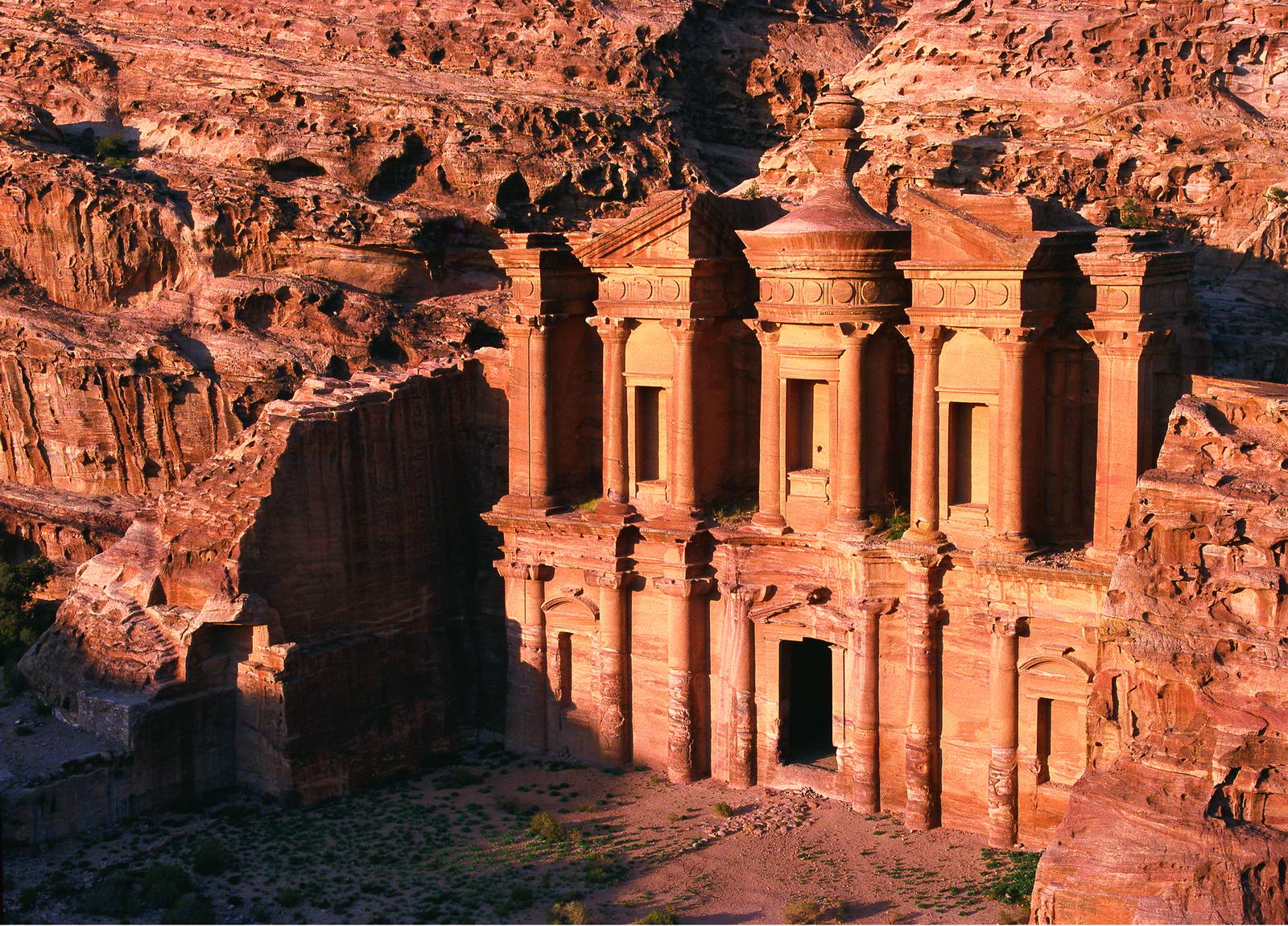
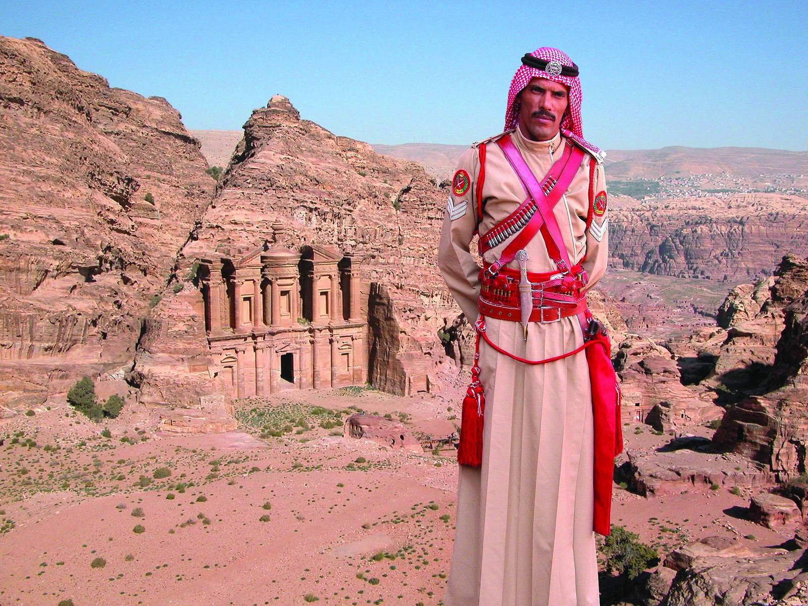
The Monastery, Petra's largest monument, dates from the 1st century BC. It was dedicated to Obodas I and is believed to be the symposium of Obodas the god. This information is inscribed on the ruins of the Monastery.
Christianity found its way to Petra in the 4th century AD, nearly 500 years after the establishment of Petra as a trade center. Athanasiusmentions a bishop of Petra (Anhioch. 10) named Asterius. At least one of the tombs (the "tomb with the urn"?) was used as a church. An inscription in red paint records its consecration "in the time of the most holy bishop Jason" (447). After the Islamic conquest of 629–632 Christianity in Petra, as of most of Arabia, gave way to Islam. During the First Crusade Petra was occupied by Baldwin I of the Kingdom of Jerusalem and formed the second fief of the barony of Al Karak (in the lordship of Oultrejordain) with the title Château de la Valée de Moyseor Sela. It remained in the hands of the Franks until 1189. It is still a titular see of the Catholic Church.
Two Crusader-period castles are known in and around Petra. The first is al-Wu'ayra and is situated just north of Wadi Musa. It can be viewed from the road to "Little Petra". It is the castle of Valle Moise which was seized by a band of Turks with the help of local Muslims and only recovered by the Crusaders after they began to destroy the olive trees of Wadi Musa. The potential loss of livelihood led the locals to negotiate surrender. The second is on the summit of el-Habis in the heart of Petra and can be accessed from the West side of the Qasr al-Bint.
According to Arab tradition, Petra is the spot where Moses (Musa) struck a rock with his staff and water came forth, and where Moses' brother, Aaron (Harun), is buried, at Mount Hor, known today as Jabal Haroun or Mount Aaron. The Wadi Musa or "Wadi of Moses" is the Arab name for the narrow valley at the head of which Petra is sited. A mountaintop shrine of Moses' sister Miriam was still shown to pilgrims at the time of Jerome in the 4th century, but its location has not been identified since.
Wikipedia